World picture GeoNetwork opensource logo
Home | Contact us | Links | About | Help |
UsernamePassword
Default view
By Group
   ISO Minimum
   ISO Core
   ISO All
By Package
   Metadata
   Identification
   Maintenance
   Constraints
   Spat. Info
   Ref. system
   Distribution
   Data quality
   App. schema
   Catalog
   Content Info
   Ext. Info
XML view
Send a reference to this record by emailPermanent link to this descriptionBookmark on DeliciousBookmark on DiggBookmark on FacebookBookmark on StumbleUpon
 

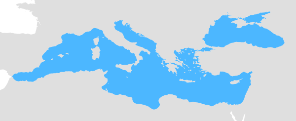
Geographic Area of Competence of General Fisheries Commission for the Mediterranean (GFCM)

ISO19115/19139 XML

Identification info
Title  Geographic Area of Competence of General Fisheries Commission for the Mediterranean (GFCM)
Date  2019-02-21
Date type  Revision: Date identifies when the resource was examined or re-examined and improved or amended
Edition  1.0
Edition date  2019-02-21
Code  fao-rfb-map-gfcm
Cited responsible party
Organisation name  FAO Fisheries and Aquaculture Department (FI)
Role  Owner: Party that owns the resource
Delivery point  Viale delle Terme di Caracalla
City  Rome
Postal code  00153
Country  Italy
OnLine resource  FAO Fisheries and Aquaculture Department (FI)
Presentation form  Digital map: Map represented in raster or vector form
Abstract  The Mediterranean Sea and the Black Sea. High seas and National waters.
Purpose  The main objective of the Regional Fishery Bodies is to ensure the sustainable exploitation of marine and freshwater resources by the establishment of a system of international regulation and by the development of marketing activities in conformity with the objectives of its members.
Point of contact
Individual name  Aureliano Gentile
Organisation name  FAO - Fisheries and Aquaculture Department (FI). Fisheries and Aquaculture Policy and Resources Division (FIA)
Position name  Information Management Officer
Role  Point of contact: Party who can be contacted for acquiring knowledge about or acquisition of the resource
Electronic mail address  Aureliano.Gentile@fao.org
OnLine resource  FAO - Fisheries and Aquaculture Department (FI)
Point of contact
Individual name  Emmanuel Blondel
Organisation name  FAO - Fisheries and Aquaculture Department (FI). Fisheries and Aquaculture Policy and Resources Division (FIA)
Position name  GIS Scientist - International Consultant in Geographic Information Systems
Role  Point of contact: Party who can be contacted for acquiring knowledge about or acquisition of the resource
Electronic mail address  Emmanuel.Blondel@fao.org
OnLine resource  FAO - Fisheries and Aquaculture Department (FI)
Maintenance and update frequency  As needed: Data is updated as deemed necessary
Graphic overview   
Map overview
Map overview
Descriptive keywords  FAO , FIGIS , fishery , fisheries , ocean management , resource management , RFB (theme).
Descriptive keywords  Area management/restriction/regulation zones and reporting units (theme).
Descriptive keywords  24561 (theme).
Descriptive keywords  fao-rfb-map-gfcm (theme).
Use limitation  The terms and conditions are available at http://www.fao.org/contact-us/terms/en
Use limitation  Usage subject to mandatory citation: © FAO, 2019. FAO Regional Fishery Bodies. Geographic Area of Competence of General Fisheries Commission for the Mediterranean (GFCM). In: FAO Fisheries and Aquaculture Department (FI) [online]. Rome. Updated 2019-02-21 [Cited <DATE>] http://www.fao.org/geonetwork/srv/eng/main.home?uuid=fa
o-rfb-map-gfcm
Use limitation  Disclaimer: The designations employed and the presentation of material in the map(s) are for illustration only and do not imply the expression of any opinion whatsoever on the part of FAO concerning the legal or constitutional status of any country, territory or sea area or concerning the delimitation of frontiers or boundaries.
Access constraints  Copyright: Exclusive right to the publication, production, or sale of the rights to a literary, dramatic, musical, or artistic work, or to the use of a commercial print or label, granted by law for a specified period of time to an author, composer, artist, distributor
Access constraints  License: Formal permission to do something
Use constraints  Copyright: Exclusive right to the publication, production, or sale of the rights to a literary, dramatic, musical, or artistic work, or to the use of a commercial print or label, granted by law for a specified period of time to an author, composer, artist, distributor
Use constraints  License: Formal permission to do something
Character set  UTF8: 8-bit variable size UCS Transfer Format, based on ISO/IEC 10646
Topic category code  Boundaries
Extent
Geographic bounding box
North bound
West bound
Polygon((-5.61 30.2639,41.7761 30.2639,41.7761 47.2805,-5.61 47.2805,-5.61 30.2639))
East bound
South bound
Supplemental Information  Regional Fishery Bodies (RFBs) are a mechanism through which States or organizations that are parties to an international fishery agreement or ("agreement" is fundamental, and different from arrangement) arrangement work together towards the conservation, management and/or development of fisheries. Some RFBs, especially those with an ecosystem mandate, work with seabirds, etc that are connected with fisheries but are not fish stocks per se.The mandates of RFBs vary. Some RFBs have an advisory mandate, and provide advice, decisions or coordinating mechanisms that are not binding on their members. Some RFBs have a management mandate, these are called Regional Fisheries Management Organizations (RFMOs). They adopt fisheries conservation and management measures that are binding on their members.The functions of RFBs also vary. They can include the collection, analysis and dissemination of information and data, coordinating fisheries management through joint schemes and mechanisms, serving as a technical and policy forum, and taking decisions relating to the conservation, management, development and responsible use of the resources.The difference between a "regional fishery body" and a "regional fishery arrangement" is that the former has established a Secretariat that operates under a governing body of member States and the latter does not have.
Distribution Information
Transfer options
Interactive Map  Geographic Area of Competence of General Fisheries Commission for the Mediterranean (GFCM)
(OGC-WMS Server: http://www.fao.org/figis/geoserver/rfb/ows?SERVICE=WMS )
View in Google Earth  Geographic Area of Competence of General Fisheries Commission for the Mediterranean (GFCM)   View in Google Earth
OnLine resource  GIS data download (WFS - GML)
OnLine resource  GIS data download (WFS - ESRI Shapefile)
OnLine resource  metadata (XML)
OnLine resource  FAO Regional Fishery Bodies
OnLine resource  Factsheet - Summary description
OnLine resource  FAO Regional Fishery Bodies (GIS Viewer)
Spatial representation info
Topology level  Geometry only: Geometry objects without any additional structure which describes topology
Geometric object type  Surface: Bounded, connected 2-dimensional geometric primitive, representing the continuous image of a region of a plane
Geometric object count 

1

Reference System Information
Code  http://www.opengis.net/def/crs/EPSG/0/4326
Codespace  EPSG
Data quality info
Hierarchy level  Dataset: Information applies to the dataset
Title  Commission Regulation (EU) No 1089/2010 of 23 November 2010 implementing Directive 2007/2/EC of the European Parliament and of the Council as regards interoperability of spatial data sets and services
Alternate title  INSPIRE Data Specifications on Area management/restriction/regulation zones and reporting units – Guidelines
Date  2010-12-08
Date type  Publication: Date identifies when the resource was issued
Date  2013-12-10
Date type  :
Explanation  The conformity to the above INSPIRE data specification has not been fully evaluated. In the absence of an explicit way to specify in ISO 19115 such absence of full evaluation, or eventual intermediate degree of conformity, and in order to fulfill the INSPIRE metadata validation, a conformity metadata element has been added (with the degree arbitrarily set to 'false')
Pass 

false

Statement  No specific methodology for the data production. The data and metadata have been published with the FAO FI GEMS tool (GIS Enforcing Metadata and Semantics) available at https://github.com/openfigis/gems
Metadata
File identifier  fao-rfb-map-gfcm
Character set  UTF8: 8-bit variable size UCS Transfer Format, based on ISO/IEC 10646
Hierarchy level  Dataset: Information applies to the dataset
Date stamp  2019-02-21T15:52:18
Metadata standard name  ISO 19115:2003/19139
Metadata standard version  1.0
Contact
Individual name  Aureliano Gentile
Organisation name  FAO - Fisheries and Aquaculture Department (FI). Fisheries and Aquaculture Policy and Resources Division (FIA)
Position name  Information Management Officer
Role  Point of contact: Party who can be contacted for acquiring knowledge about or acquisition of the resource
Electronic mail address  Aureliano.Gentile@fao.org
OnLine resource  FAO - Fisheries and Aquaculture Department (FI)
Contact
Individual name  Emmanuel Blondel
Organisation name  FAO - Fisheries and Aquaculture Department (FI). Fisheries and Aquaculture Policy and Resources Division (FIA)
Position name  GIS Scientist - International Consultant in Geographic Information Systems
Role  Point of contact: Party who can be contacted for acquiring knowledge about or acquisition of the resource
Electronic mail address  Emmanuel.Blondel@fao.org
OnLine resource  FAO - Fisheries and Aquaculture Department (FI)